Maps Page Index:
Computer generated maps using GPS gathered WGS 84 based waypoints NOTE: this link takes you to a separate page.
Maps I've created, and I offer to make more!
My philosophy of maps
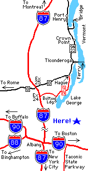
Directions Map
This map shows clearly certain Interstate Highways and major roads. A clearly visible star and the word "Here!" shows clearly where your destination is. I've deliberately changed the destination to be generic, and not connected with any roads. This map is intended to be a "directions to a specific place" map and if completed, could show clearly how to get to any given location, yet have a map area that is large enough to easily locate the region on a state road map. The map can be easily made to have a clear background so there are no edges between the map and the rest of the web page it is on. The map is not to scale by any means, but that is OK with these types of maps.
Location Map
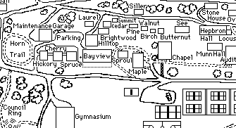
This map shows detail at a specific location. It is just a small portion of a much larger map. While this map is all black and white, it could be easily color coded. This map shows clearly the locations and names of buildings even in a crowded area. The relative position of each building with respect to the others can be clearly seen. The name of each building is also clearly readable, and it is reasonably easy to determine which name goes with each building or parking area. This map was originally scanned into the computer, with a resulting image that was very blocky when looked at in black and white with standard screen resolution. I spent several hours going through the entire map pixel by pixel and making all lines straight or at least unbroken and clearly readable. Anyone not familiar with this area could easily find their way around. Anyone who is familiar with this area will know immmediately that this map is just a small piece of a much greater place.
If you would like me to make a map for you, please e-mail me at Bill222E@ensingers.com for information.
Here is an example. Most subway and rail transit maps that I have seen (with the exception of older New York subway maps circa 1950's) are reasonably clear and have sufficient detail to find the location of stations at both your origin and destination points. However, many bus transit maps are much more difficult to read. Often the route travelled is not easily distinguishable from the streets on which the bus travels, and bus stops even less distinguishable. Also, the availability of such maps usually are not as good, especially at bus stops. I also believe that maps of the local area at bus and rail transit stops would be of great benefit. (This is done in the Washington DC Metro and perhaps other systems, but is by no means universal.)
My maps may not have that professional polish, but they are detailed, accurate, and easy to read.
If you are interested in any of this stuff, please e-mail me at Bill222E@ensingers.com. When you write, please let me know how you found my page and the address for your web page if you have one.